


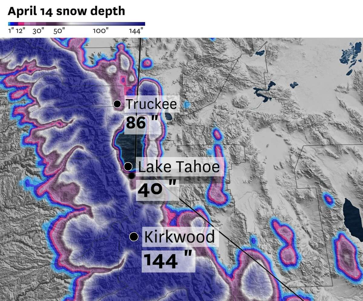
The latest snow depths around the Tahoe area, with lower elevations around South Lake Tahoe still dealing with over three feet of snow, while peaks and summits above 7,000 feet have as much as 12 feet of accumulated snow.
Baron/LynxMuch of California is in the midst of a warming trend this weekend as a ridge of high pressure builds over the center of the state.Weekend highscan be expected in the 60s by the coast and bays and 70s in the Central Valley. This warmth is looking to extend into the Sierra, particularly around Lake Tahoe.
A few Sierra summits above 7,000 feet are likely to reach daytime highs this weekend in the upper 40s and lower 50s, raising concerns about snowmelt. This means that creeks and rivers that flow out of the Sierra Nevada and into communities that surround Lake Tahoe could deal with spillover, leading to minor flooding in areas that are still recovering from winter’s storms.
Sunny skies and flood risks
A warm, dry ridge of high pressure is looking to expand into the Sierra, raising weekend temperatures well above freezing while also stomping out cloud cover. The combination of ample sunshine and warm air will make for more snowmelt, adding to the region’s rivers and streams.

Saturday afternoon’s daytime highs, with widespread 40s and 50s on tap for much of the Sierra Nevada, while temperatures in the foothills could easily jump to the 60s.
Baron/LynxMany creeks and watersheds in the foothills of the Sierra are filled to the brim as snow from the historic snowpack melts. This weekend’s warm-up has raised questions over flooding risks for the Tahoe area and metropolitan areas downstream of the Sierra Nevada, including parts of Fresno, Bakersfield and Reno.
Because of the moderate flood potential, the National Weather Service issued aflood watchfrom Saturday afternoon through Monday morning for the Tahoe area, some slopes in Lassen and Plumas counties and parts of Nevada, including some foothills near Reno.
The main concern is that creeks and streams stemming from the Sierra will be running high, leading to flooding in low-water crossings along the Susan, Carson and East Walker rivers. Those caught in the path of flooding will be dealing with cold waters, which can lead to shock.
Should residents come across rising floodwaters, it’s best to turn around. Avoid closed-off roads and monitor updates to National Weather Service watches and advisories, and take action should flooding occur in your area.


Saturday Breakdown
San Francisco:A few morning clouds are forecast across the west side as a light breeze develops along Ocean Beach and Lake Merced. Most clouds will dissipate by noon as an area of high pressure settles across the city. Its winds will spill over Twin Peaks, Mount Davidson and Bernal Heights, spreading out by the afternoon.
Saturday’s weather setup will ramp up winds downtown and in the Mission, with afternoon gusts up to 20 mph. But because of the ample sunshine and dry air, highs are slated to reach the upper 50s on the west side and about 60 east of Sutro Tower.
Pacific Coast and Peninsula:Stray morning fog is on tap for parts of the coast along Highway 1 between Pacifica and Half Moon Bay. Most of it will lift after 9 a.m., becoming stratus — or high fog — by midmorning.
A ridge of high pressure will build across the Peninsula by afternoon, making way for sunshine. Daytime highs will reach the lower to mid-60s along the San Bruno Gap, including Daly City, Millbrae and San Francisco International Airport. Upper 60s will be possible along San Andreas Lake and most of the I-280 and 101 corridors south of San Mateo, including Redwood City, Atherton and Foster City.
North Bay:A cool breeze on the coast and bays and warmer air inland will result in stark differences in daytime temperatures across Marin, Sonoma, Napa and Solano counties.
Residents in Novato, San Rafael, Tiburon and Benicia can expect a steady rise in temperatures through the morning as partly cloudy skies recede. The warmth will be offset by the afternoon breeze off San Francisco Bay, keeping highs from passing 60. It’ll be a different story for the Petaluma, Napa and Santa Rosa valleys, where warmer air and calmer winds will result in daytime highs in the lower 70s.
East Bay:Aside from patchy clouds along the Oakland and Berkeley hills, skies are looking to become mostly sunny across most of Alameda and Contra Costa counties this afternoon. Look for a light breeze along the delta and the bayside, including Concord, Richmond, Oakland, Alameda and Hayward. Temperatures by the water are looking to reach the lower 60s, with a few mid-60s on some of the hillsides around Berkeley and Albany.
This afternoon’s cool breeze isn’t looking to go past the Caldecott Tunnel, meaning daytime highs are likely to reach the upper 60s in the San Ramon and Livermore Valleys. A few spots in and around Walnut Creek, Dublin and Pleasanton could reach 70 degrees by midday before temperatures fall back to the 50s and 40s after sunset.
South Bay and Santa Cruz:温暖,干燥的空气在圣克拉拉瓦尔预计ley on Saturday, clearing out most of the morning clouds by 11 a.m. Sunshine will raise highs to the lower 70s in most of San Jose and the foothills, including the Cupertino Hills and the Highway 17 pass in Los Gatos. Lower 70s are also on tap for the 101 corridor between Morgan Hill and Gilroy, with mid-70s possible closer to the Diablo Range.
Saturday’s warm-up will be offset along Monterey Bay by an afternoon breeze, keeping temperatures closer to the mid-60s in Capitola, Aptos, Watsonville and Soquel. Some of this breeze could stream north along Highway 17 and into the Santa Cruz Mountains, keeping afternoon highs in the lower 60s across Felton, Scotts Valley and Ben Lomond.
Reach Gerry Díaz: gerry.diaz@sfchronicle.com; Twitter: @geravitywave


