


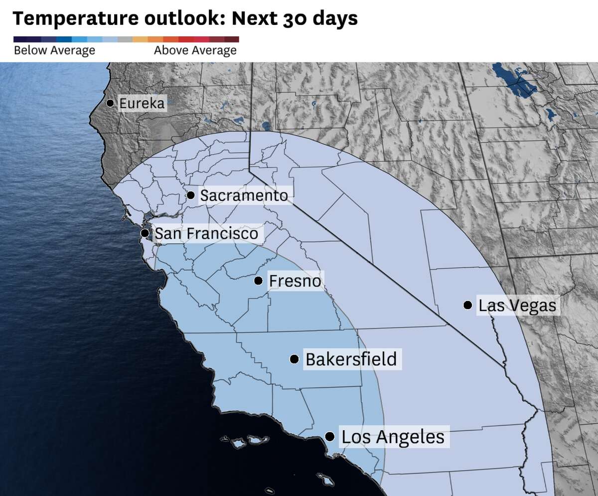
The Climate Prediction Center’s temperature outlook for May, with the chances for below-average temperatures increasing as you head toward the Central Coast. Other noteworthy areas include the Bay Area’s inland valleys and the Los Angeles metro area.
Baron/LynxMay is set to start off a lot like February, as chances for rain and snow return to parts of the state — along with the risk for isolated thunderstorms. Metaphorically speaking, winter doesn’t seem to be done with California, as weather models hint at more low-pressure systems on the horizon.
The outlook for the first half of the month is riddled with unsettled, winter-like conditions, though weather models also indicate a return of another setup: the May Gray. Long-range weather models are trending toward a pattern where the next few weeks will feel a lot like a hodgepodge of winter weather mixed with the more typical ebb and flow of marine fog, depending on where you are in the state.
What’s on tap for May
California is poised to lock into a weather pattern chock full of troughs of low pressures. These lows often develop around 5,000 feet above ground, carving out a gap in the atmosphere like a knife cutting into a slab of butter. When these lows form off the coast, the gap they leave behind allows moisture and cold air over the Pacific Ocean to rush toward San Francisco and the wider Bay Area.
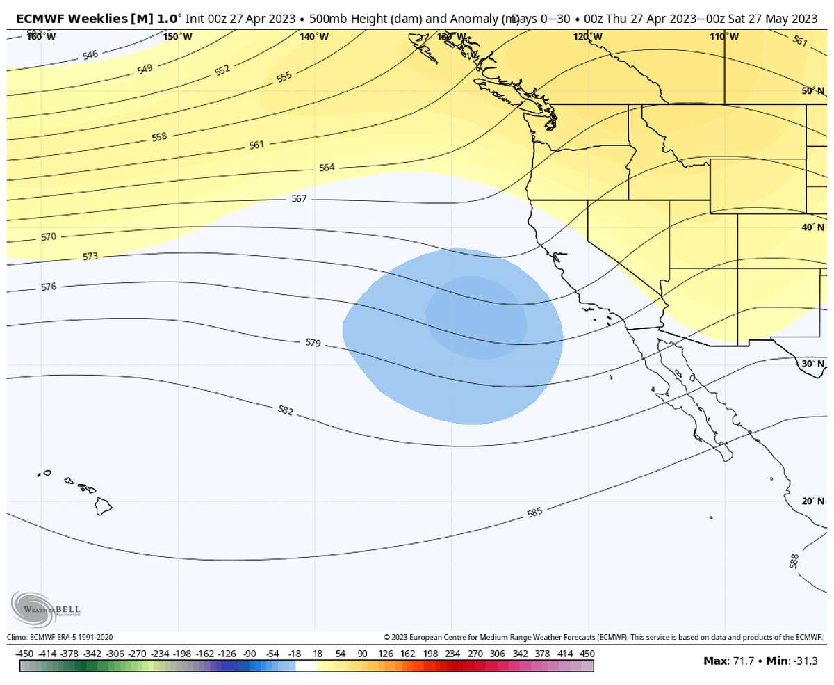
欧洲的天气模式的扩展前景May showcases where anomalous areas of lower pressure are likely to develop. The blue-shaded area corresponds to an elevated chance of low-pressure systems, leading to higher chances of unsettled weather in the mountains and fog returning.
Baron/Lynx气候模型表明波谷的low pressure are likely to form just off the coast of California over the next few weeks, meaning that there is a high chance that temperatures will run below average along the shoreline, bays and delta regions of the Bay Area. The signal also means that these cold snaps could stream rounds of moisture into Northern California, allowing for what’s often referred to as May Gray — the constant flow of fog that develops around this time of year — to kick off right on cue.
But fog isn’t the only type of moisture set to roll in. Depending on the intensity of the low-pressure systems, May’s outlook could also call for the return of drizzle and light showers over the course of the month.

The Climate Prediction Center’s outlook for the first few days of May highlights above-average chances of precipitation across Northern California, the Bay Area, Central Valley, Central Coast and the Los Angeles area.
Baron/Lynx根据气候预测中心,这我s most likely to play out along the immediate coast, with towns and cities along Highway 1 from Mendocino to Point Conception set to have the highest chances of precipitation.
五月的第一周将看到的节目ers across parts of Northern California, including the Bay Area and Santa Cruz Mountains. The earliest showers will arrive Monday night, with the bulk on Tuesday. Up to a third of an inch of rain is expected across most of the Bay Area while a half an inch to an inch is forecast in the hillsides. The Santa Cruz Mountains are likely to be in the bull’s-eye for most of Tuesday’s showers, with totals exceeding an inch across the summits near Ben Lomond.
At this point, the rain outlook doesn’t indicate heavy downpours in May. Instead, weather models suggest there will be a heightened possibility of light showers scattered throughout the month across the Bay Area’s shoreline.


What about the Sierra?
Communities downstream of the Sierra Nevada have been experiencing some of the most pronouncedflooding from snowmeltin recent memory, with places in Kings and Kern counties and parks likeYosemite National Parkremaining closed to the public out of concerns for more flooding. It’s not looking like there’s an immediate end in sight for these flood concerns.
Snow showers are forecast to fall at the summits surrounding Lake Tahoe starting Sunday, with more widespread showers at lower elevations closer to Interstate 80 by Monday. The highest elevations of the Tahoe region can expect between 5 to 8 inches of snow, while a little accumulation is expected in the valleys below 6,000 feet — up to half an inch of snow. The Central and Southern Sierra’s summits are also expected to have fewer accumulations — only 1 to 4 inches above 6,000 feet and trace amounts in the valleys. The setup for the first week of May won’t lead to major changes to the depth of the wider snowpack across the Sierra Nevada.
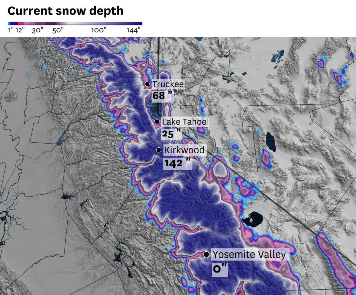
The Sierra Nevada snowpack at the end of April, with several stations still measuring large quantities of snow along the range’s summits.
Baron/LynxThe snowpack as of Friday was still running 219% above average in the Northern Sierra, 253% in the Central Sierra and 336% in the Southern Sierra, even after April’s heat wave. Snow showers on Monday and the cooler air won’t do much to slow down the ongoing snowmelt that’s under way, especially in the rivers and streams around Yosemite in the Central Sierra and the Tulare Basin on the foothills of the Southern Sierra. The Climate Prediction Center is calling for cooler than average temperatures for most of the Sierra Nevada, but longer days and shorter nights will inevitably lead to warming soils and the melting of the snow closest to the ground.
In other words, there is still plenty of snow left to melt away in the coming months.
The heightened chances for May precipitation includes the risk for isolated thunderstorms. Like the cold low-pressure systems that clogged the skies of California with thunderstorms during winter, May’s systems could reel in convective showers to parts of the state, including the Sierra foothills. These thunderstorms aren’t likely to bring major risks for wildfire starts, since most would be isolated and wet.
Cold low-pressure systems are likely to continue rolling into California through mid-May, bringing light snow to the mountains. But by then the days will be another 10 to 20 minutes longer, leading to more sunlight that will chip away at the snowpack. Albedo — how reflective a surface is — in the Sierra has already gone down as increasing sunlight melts snow, exposing darker soils and fields. This will lead to a feedback loop where the ground warms and melts more snow, exposing greater areas with darker soils that absorb more sunlight and warmth and so on.
In other words, flooding concerns in the Central Valley’s rivers and lake beds won’t be going away in May.
Reach Gerry Díaz: gerry.diaz@sfchronicle.com; Twitter: @geravitywave


