


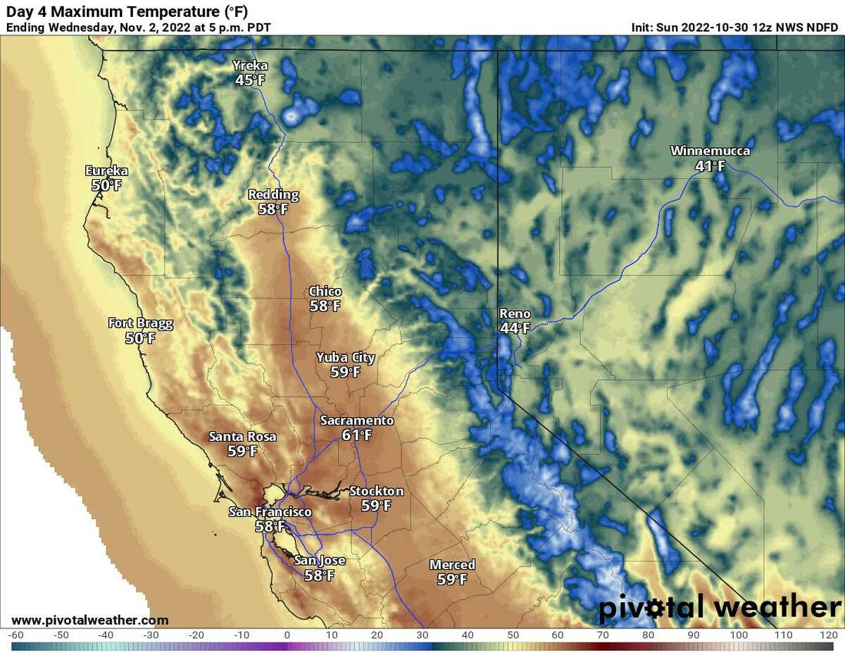
Wednesday will be cold with highs in the upper 50s to near 60 degrees across the Bay Area.
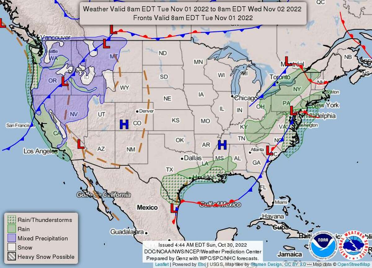
Trick-or-treaters probably won’t need an umbrella on Monday. But after a cool, breezy and mostly cloudy Halloween, temperatures will take a dive as acold front passesthrough the region on Tuesday.
The best part will be thechance of rainit brings along with it.
Monday morning fog will be spotty across the Bay Area and will last until 9 a.m. Skies will be filtered with clouds, and highs will be slightly cooleracross the Bay Areathan they were over the weekend.
San Francisco, Oakland and the East Bay shoreline, along with North Bay cities that are closer to the water, will reach the lower to mid-60s. Coastal spots will reach the upper 50s to low 60s. Inland and valley cities will reach the lower to mid-70s.
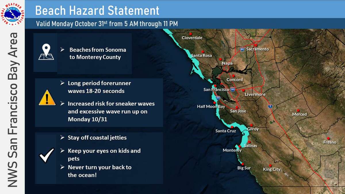
Dangerous swim and surf conditions are expected along the coast on Monday.
If you plan on heading to the beach on Monday, dangerous swimming and surfing conditions are possible. Strong rip currents and sneaker waves could happen anytime, especially on beaches that face the northwest.
Tuesday will bring a change in the weather pattern, with cold front due to move through the region and a chance of rain and gusty winds. The chance of showers will start before the sun comes up and continue through the evening rush hour. Lingering showers will be possible Tuesday night through Wednesday night. The Bay Area may be able to squeeze out up to 0.10 inches of rain.
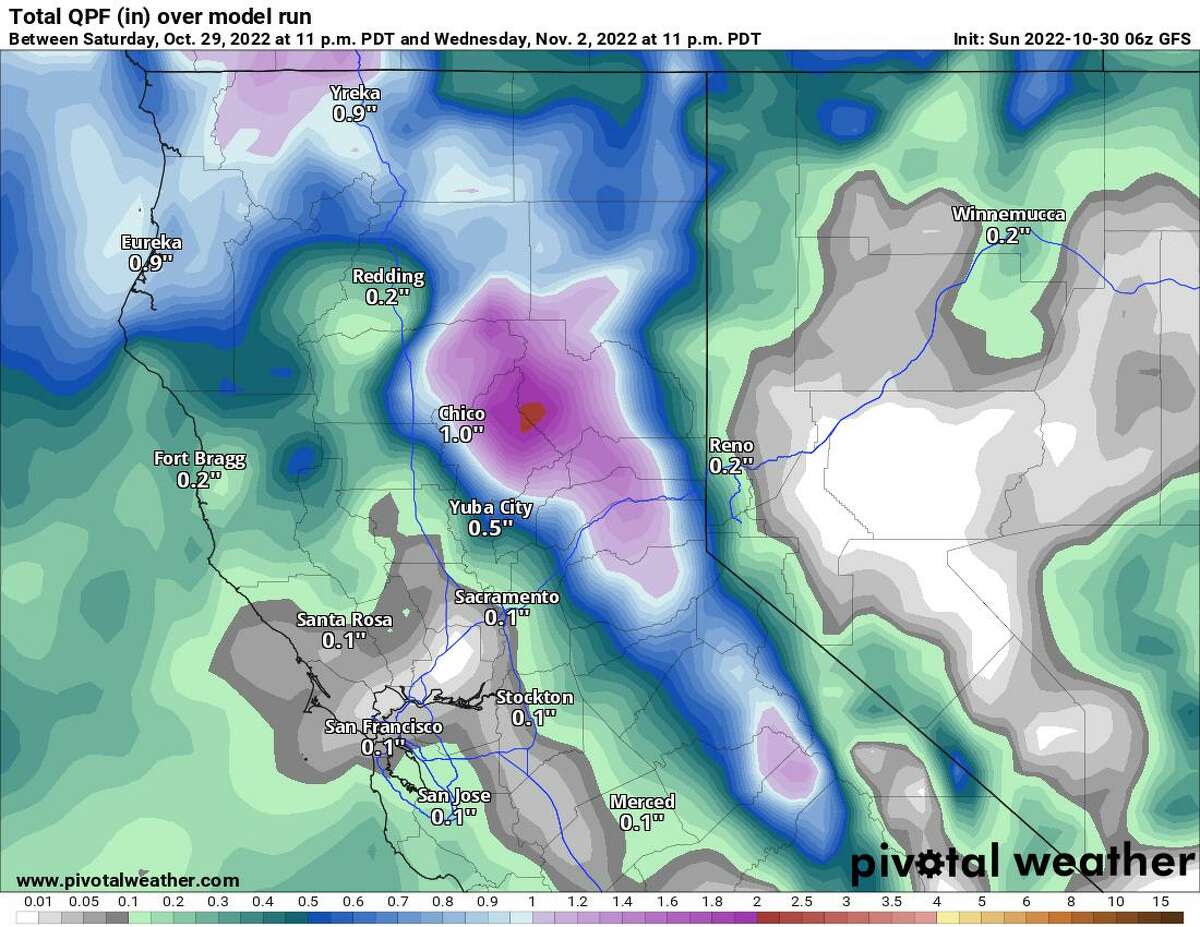
Global Forecast System’s model run of total precipitation through 11 p.m. Wednesday
Monday breakdown
Though no rain will dampen trick-or-treating, as the sun goes down after 6 p.m. temperatures will go down with it. The breeze will make the temperature feel colder, so plan on bringing a warm jacket to wear over your costume.
San Francisco:The city will see lows in the lower 50s and highs mostly in the lower 60s. Areas west of Highway 1 will be a few degrees cooler, with highs in the upper 50s. Skies will be covered with clouds, and winds will be breezy from the west around 10 mph until 1 p.m. Winds will pick up further during the afternoon and evening.
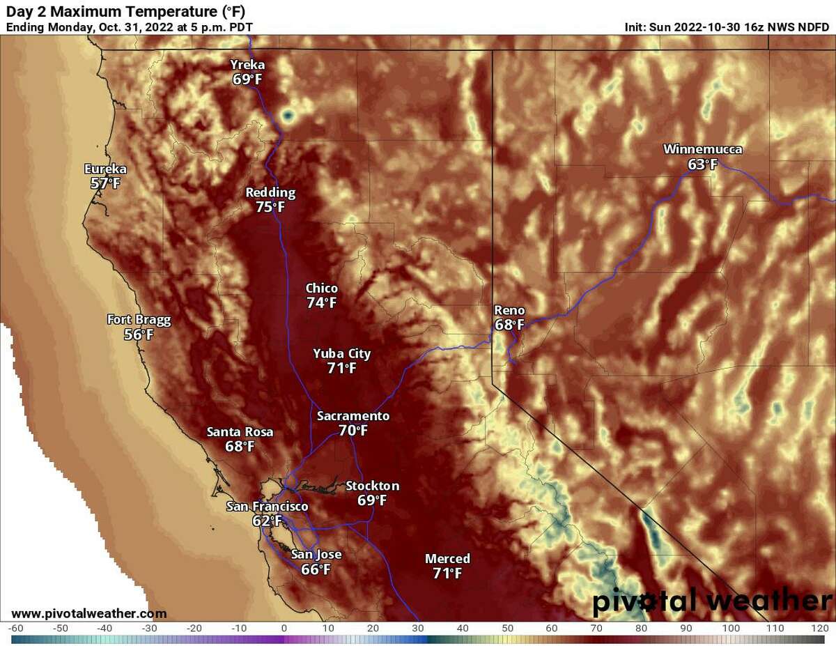
Monday’s forecast highs
Pacific Coast and Peninsula:The morning will hover around 50 degrees across the Peninsula and upper 40s along the coast. Across the mid-Peninsula, Brisbane, South San Francisco, and the airport, highs will reach the lower 60s. For areas south of the airport, highs will reach the mid-60s. Highs will reach the upper 50s along the coastline. Skies will be cloudy at the beaches, which will have a breeze from the northwest between 10-20 mph, and the Peninsula will be mostly cloudy during the afternoon.
North Bay:The morning will start off colder for the valley with lows in the middle to upper 40s, and the rest of the North Bay will be a few degrees up from that. Skies will be partly cloudy and winds will be breezy from the west/southwest between 10-20 mph for cities closer to the water.
这将是一个冷启动马林县,lows in the upper 40s. By the afternoon, highs will reach the mid-60s for Mill Valley and upper 60s for Novato and San Rafael. Sausalito and the Tiburon peninsula will be much cooler with highs in the upper 50s.
In the Petaluma Valley, there will be patchy dense fog until around 9 a.m. Highs will reach the upper 60s there as well as in Rohnert Park and Santa Rosa. From Windsor to Healdsburg, highs will reach the lower 70s. Winds in this part of the valley will be lighter from the southwest between 5-10 mph.
In Napa County, patchy dense fog is possible until 9 a.m. Highs will reach the mid-60s for Napa. The rest of the wine trail will reach the upper 60s. Winds will blow from the southwest between 5-10 mph. In Solano County, skies will be a mix of clouds and sunshine. In Vallejo, Benicia and along Interstate 80 to Fairfield, highs will reach the middle 60s.
East Bay:The morning will start off with partly cloudy skies and lows in the upper 40s inland to the lower 50s closer to the water. In the afternoon, highs will reach the lower 60s for the East Bay shoreline and upper 60s to near 70 degrees for inland cities. Expect a southwest wind between 5-10 mph.
Oakland, Richmond and Berkeley will reach the lower to mid-60s, below average for the area. Highs will be similar along the Interstate 880 corridor from San Leandro to Fremont. Along Highway 4, Martinez and Antioch and the city of Brentwood will reach the mid- to upper 60s. Inland spots along Interstate 680 and cities east will peak near 70 degrees. A couple of spots in the Amador Valley, such as Dublin, San Ramon and Pleasanton, will reach the upper 60s.
South Bay and Santa Cruz:Across the Santa Clara Valley, the morning will start off cold with lows in the upper 40s. Skies will be mostly cloudy throughout the day; expect a light breeze from the northwest between 5-10 mph. San Jose and n eighborhoods that are north of Highway 82 will reach the mid-60s. Saratoga, Los Gatos, Morgan Hill and Gilroy will reach the upper 60s.
In Santa Cruz County, the morning will start off chilly with lows in the mid- to upper 40s. Clouds will cover the sky and keep temperatures cool. Highs will reach the lower 60s for Santa Cruz. Boulder Creek to Felton will reach the upper 60s to the lower 70s. Scotts Valley will reach the mid-60s by the afternoon.
冷锋将通过星期二,布林ging chances of rain and colder temperatures to the Bay Area.
On tap this week
The cold front that impacts the Bay Area on Tuesday with showers and gusty conditions will leave behind colder air. Tuesday will carry the best chance of precipitation, but a few lingering showers will be possible on Wednesday; otherwise plan on mainly sunny skies.
Daytime temperatures will be coolest by Wednesday, with San Francisco topping off in the upper 50s. The Santa Clara valley in the South Bay will fare similar, with highs in the upper 50s to lower 60s. Cities closer to the bay, like Oakland, will reach the upper 50s to near 60 degrees. Highs will be noticeably cooler for East Bay inland spots and North Bay valley towns with highs in the lower 60s. Fog, mist and drizzle will be possible Wednesday and Thursday mornings, followed by clear and sunny skies Thursday and Friday.
Starting Thursday, highs will gradually increase, but will still be running around 5 degrees below seasonal average through Saturday.
Michelle Apon is a San Francisco Chronicle newsroom meteorologist. Email: michelle.apon@sfchronicle.com Twitter: @MichelleApon


