


The start of May is bringinga shift in the weather to the Bay Area, in stark contrast to the warm and dry end of April.
Cooler temperatures and the chance for thunderstorms will be arriving inCaliforniaon a low-pressure system coming from the Pacific Northwest. Weather models are predicting temperatures 5 to 15 degrees below early-May averages, cold enough for wintry weather to return to the Sierra Nevada and slow theongoing snowmelt.
Overall, the first five days of the month are likely to be the Bay Area’s coldest start to May in at least 15 years.
A “cut-off low”
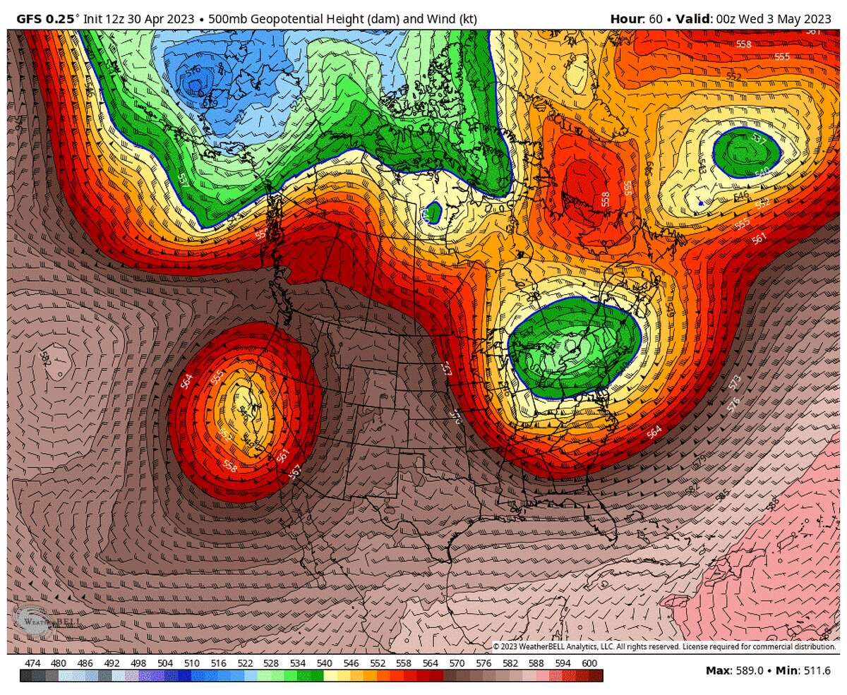
Unlike the low-pressure systems that brought heavy precipitation and strong winds to the Bay Area throughout the winter, this week’s system is what’s known as a cut-off low.
These systems are distinct because they “cut off” from Earth’s westerly current, something that did not occur with many of the Bay Area’s relentless winter systems. Cut-off lows typically aren’t large rainmakers but tend to be stationary for days or weeks at a time.
This week’s cut-off low air will be unseasonably cold – but not as cold as the winter, since the springtime higher sun angle will warm daytime temperatures into the 50s near the water and 60s inland.
Daytime rain showers will become more frequent this week, with the sun acting like a stove heating a pan of popcorn. Pinpointing the location of these “popcorn showers” is tricky, but the region will see threats of thunder, lightning, heavy downpours and small hail.
On tap this week
Monday’s temperatures will drop even lower than Sunday’s cool-off. Many areas will struggle to hit 60 degrees, the exception being inland areas of the North and East Bay that could push into the mid-60s. Cloud cover will be extensive, and evening rain chances highest for the South Bay and Santa Cruz County. Gusts up to 30 mph also are forecast for Monday, and strongest in San Francisco and the Pacific Coast.
周二可能功能fo最高的机会r widespread Bay Area thunderstorms. Thunderstorms will feature infrequent lightning, small hail, heavy downpours and locally gusty winds. Highs will be similar to Monday, but temperatures may temporarily drop into the low 50s under heavy showers.

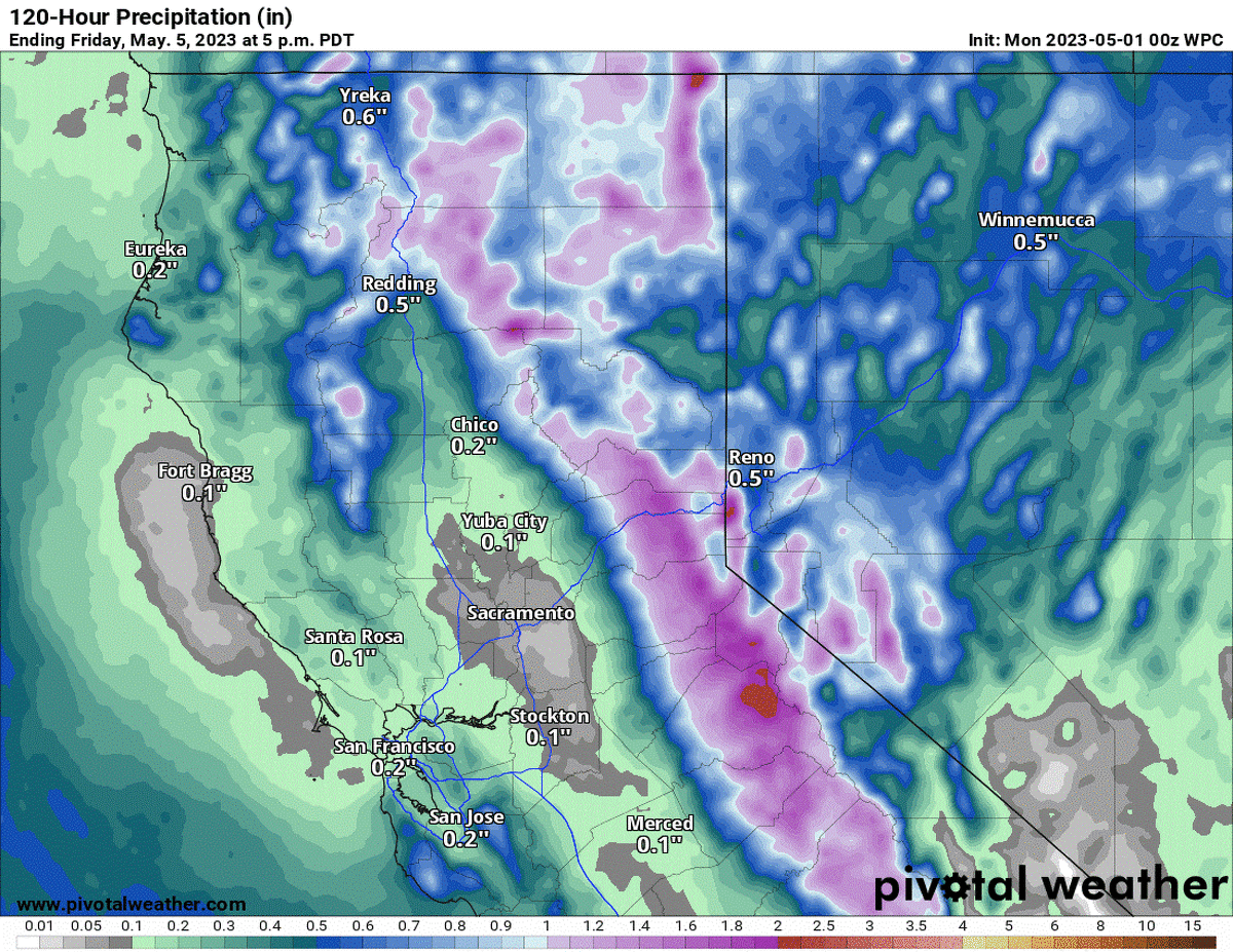
Thunderstorm chances decrease Wednesday, despite numerous rain showers, especially in the southern Bay Area. The Santa Cruz Mountains could see the most precipitation, up to half an inch in 24 hours. An occasional lightning strike remains possible Wednesday, the highest chances being in the South and East Bay.
By Thursday and Friday, the low-pressure system will weaken and begin moving east, allowing the marine layer to return to the coast. Fog and light drizzle are possible near the ocean on Thursday and Friday mornings, as well as lingering showers. Temperatures will remain below normal, in the 50s and 60s.
Monday breakdown
San Francisco:Chilly temperatures, gusty winds and extensive cloud cover kick off the month. Morning temperatures, around 50 degrees, will struggle to warm throughout the day, as cool ocean air blows toward the city.
The Presidio, the Sunset and Richmond districts and Lake Merced will be shrouded in clouds for most of the day with temperatures in the low to mid-50s. Drizzle and gusts up to 35 mph will make it feel even colder.
Noe Valley, South of Market, the Mission and other areas east of Sutro Tower will start with patchy morning fog, then approach 60 degrees with some sun breaks by the afternoon. Wind gusts up to 25 mph will make the air feel more like winter than mid-spring, though.
Rain showers will increase overnight Monday into Tuesday morning, with a few hundredths of an inch anticipated. Overnight temperatures will fall into the mid- to upper 40s.
Peninsula and Pacific Coast:Rain chances are possible throughout the day. Gusts up to 30 mph will push in morning clouds and drizzle for Daly City and Pacifica, with temperatures in the low 50s. A brief break is possible for the afternoon, but more widespread showers will arrive by the evening and overnight..
Steady winds through the San Bruno gap will keep temperatures in the upper 50s for Millbrae and San Mateo and raise the chance for morning drizzle. Redwood City and southeastern San Mateo County will climb toward 60 degrees.
Chances of rain increase by midnight. Numerous showers could drop up to a tenth of an inch on El Granada and Half Moon Bay, with more scattered showers elsewhere. Lows will be in the upper 40s.
North Bay:The warmest Bay Area spot on Monday will be in the North Bay, with highs in the mid-60s in Marin County, including San Rafael and Mill Valley, and the Santa Rosa, Petaluma and Napa valleys.
The day will start cool and overcast, though, with temperatures in the mid-40s. The afternoon will see partly sunny skies and west winds at 15 mph in the afternoon.
Point Reyes and western Marin County will be shrouded in low clouds throughout the day and see the sky thicken up more in late evening as rain showers approach. Monday night temperatures will fall into the low to mid-40s with light rain showers dropping up to a tenth of an inch.
East Bay:Another cool and windy day is in store, with morning temperatures in Oakland and Berkeley near 50 degrees and remaining in the 50s throughout the day, with cool gusts blowing across the bay.
上午小雨是可能的里士满,奥尔巴尼,Alameda and the Oakland Hills due to these moist winds. A short-lived dry break in the afternoon, with temperatures in the upper 50s, will be followed by more rain showers overnight and temperatures in the upper 40s.
Walnut Creek and Dublin will be the East Bay’s warmer spots Monday, with temperatures climbing to the mid-60s under partly sunny skies. Fremont will see temperatures in the low 60s with mostly cloudy skies.
Low clouds will partially clear during the afternoon before rain showers return around midnight. Accumulation Monday night will be light.
South Bay and Santa Cruz:Monday will be mainly dry during the day before rain chances pick up overnight.
Temperatures will start out around 50 degrees for Palo Alto, Santa Clara, San Jose and Santa Cruz, with mid- to upper 40s at higher elevations. Skies will clear partially during the afternoon for temperatures around 60 degrees.
Showers arrive by the evening for the Santa Cruz Mountains and will become more widespread overnight. Weather models are predicting a tenth to a quarter of an inch of rain in Boulder Creek and Scotts Valley by Tuesday morning, with a few hundredths of an inch for Santa Cruz and the Santa Clara Valley.
Anthony Edwards is a contributing meteorologist for The San Francisco Chronicle.


